


Mallorca Topo Maps
Deskripsi Mallorca Topo Maps
+++ GPS Baru Pemetaan App +++
Mudah digunakan Outdoor / Offline GPS aplikasi navigasi dengan akses ke yang terbaik peta topografi dan foto udara untuk Mallorca.
++ Untuk penggunaan offline fitur PRO diperlukan! ++
Hidupkan Andoid Phone / Tablet menjadi GPS luar ruangan untuk perjalanan ke pedalaman TANPA CELL CAKUPAN. Aplikasi ini memberikan Anda pilihan yang sama pemetaan seperti yang mungkin Anda tahu dari handheld Garmin atau Magellan GPS.
Termasuk lapisan peta GRATIS:
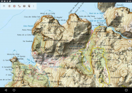
• Mallorca Topo Peta: Mapa Topográfico Nacional 1: 50.000 & 1: 25.000 (IGN MTN25 & MTN50)
• Mallorca Peta Dasar: IGN Basis Topográfica Nacional 1: 25.000 (BTN25 & BCN25)
• Mallorca Citra: Resolusi tinggi citra udara. Rencana Nacional de Ortofotografía Aérea (PNOA)
• Pendaftaran Tanah Peta: Cartografía Catastral
• OpenStreetMap: ini peta crowdsourced adalah tambahan yang sangat berguna untuk lapisan peta lainnya. Berisi banyak fitur unik.
• OpenCycleMaps: peta ini sangat ideal untuk merencanakan perjalanan sepeda
• ESRI Topografi
• Gambar ESRI Aerial
• ESRI Street Map
• Google Road Map (akses online saja)
• Gambar Google Satellite (akses online saja)
• Peta Google Terrain (akses online saja)
• Bing Road Map (akses online saja)
• Gambar Bing Satellite (akses online saja)
• Earth At Night
• overlay Hillshading
Fitur utama untuk outdoor navigasi:
• Membuat dan mengedit Waypoints
• GoTo-Waypoint-Navigasi
• Track Recording (dengan kecepatan, ketinggian dan profil akurasi)
• Tripmaster dengan kolom untuk odometer, kecepatan rata-rata, bantalan, elevasi, dll
• GPX / KML / KMZ Ekspor
• Cari (nama tempat, POI, jalan-jalan)
• datafields Customizable di Peta dan Tripmaster (mis Kecepatan, Jarak, Kompas, ...)
• Berbagi Waypoints, Trek atau Rute (melalui eMail, Whatsapp, Dropbox, Facebook, ..)
• Tampilan koordinat di Lat / Lon, UTM atau MGRS / usng (Military Grid / US National Grid)
• Rekam & berbagi lagu dengan statistik & profil elevasi
• peta Putar (Melacak Up & Utara Up)
• Dapatkan Elevation dengan klik panjang di peta
• Track Replay
• dan masih banyak lagi ...
Tersedia fitur Pro: (fitur Pro tersedia melalui Dalam App Pembelian)
• Offline Gunakan - tidak ada sel cakupan dibutuhkan
• Mudah + Cepat Massal-download ubin peta untuk OFFLINE PEMAKAIAN (tidak untuk peta Google dan Bing)
• Membuat dan mengedit Rute
• Route-Navigasi (Point-to-Point Navigasi)
• GPX / KML / KMZ Impor
• unlimited Waypoints & Lintasan
• Tambahkan Peta lainnya Tile-Server
• Tanpa iklan
Gunakan Offline:
Semua ubin peta melihat disimpan dalam cache. Cache daerah yang luas Anda perlu membeli fitur Pro.
Gunakan aplikasi navigasi ini untuk kegiatan di luar ruangan seperti hiking, bersepeda, berkemah, mendaki, berkuda, ski, kano, berburu, offroad 4WD wisata atau mencari & rescue (SAR).
Tambahkan waypoints kustom di bujur / lintang, UTM atau format MGRS / usng dengan WGS84 datum.
Impor / Ekspor / Share GPS-Waypoints / Lintasan / Rute di GPX atau format Google Earth KML / KMZ.
Preload data peta GRATIS untuk wilayah tanpa layanan seluler (fitur Pro!).
Komentar dan permintaan fitur untuk mallorcamaps@atlogis.com
Silahkan lihat pada aplikasi navigasi outdoor lainnya: https://play.google.com/store/search?q=atlogis
+++ Kami TIDAK melacak aktivitas pengguna atau mengumpulkan data pengguna! +++
Mallorca Topo Maps - Versi 7.7.2
(22-03-2025)Mallorca Topo Maps - Informasi APK
Versi APK: 7.7.2Paket: com.atlogis.mallorcaVersi Terakhir dari Mallorca Topo Maps
Versi lain


 3.79
3.79


Aplikasi pada kategori yang sama

Anda juga mungkin suka...
Aplikasi pada kategori yang sama


